About Us
In May of 2000, when the United States discontinued its use of Selective Availability, I started building the most accurate and comprehensive geospatial database of directly observed hiking trails and maps to keep track of the trails that I hike. Over the years, I published many trail maps and my first printed trail guide in 2004, while hiking thousands of miles every year.
A decade later, I was building trail maps for handheld GPS devices. As smartphones gained prominence, I shifted my focus to mobile platforms. The U.S. trail maps use 1:24,000 scale topo maps as a base layer and many of them include state and BLM land boundaries, something that's not included on typical topo quads. I stitch the map sheets together and build custom quads with my data and overlap adjacent quads. You can download the maps to any file folder that you choose and manage. Best of all, the maps do not require a specific app or cell phone service, they can be used with the free Custom Maps app, Google Earth Pro on desktop, and many other apps and geobrowsers.
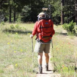
That's me, wearing a custom pack that I made to measure trails. In this photograph I'm measuring a section of the AZT at the north rim of Grand Canyon National Park. The shiny disk above my head is a base plate for reducing the probability of multipath to the antenna, primarily reflections from the ground.


The center image is a prototype of my first printed trail guide, "England, Backpacking Dorset", dedicated to the men and women who fought against Nazi Germany during the Second World War.
If you're interested, here's some articles I published many years ago:
Elevation Services
Illegally Constructed Trails
Cartographic Spam
Cartographic Vandalism
Crowd Sourced Trail Data
Snap to Trails
