Inscription Trail,
El Morro National Monument
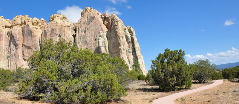
This short, wheelchair accessible loop trail should not be missed, from the trail you can see more than 2,000 inscriptions in sandstone cliffs, carved by Spanish Conquistadors and early Anglo-American pioneers. You can also see petroglyphs depicting big horned sheep, bear tracks and human hands, carved by the Ancestral Puebloans who lived here during the 13th century.


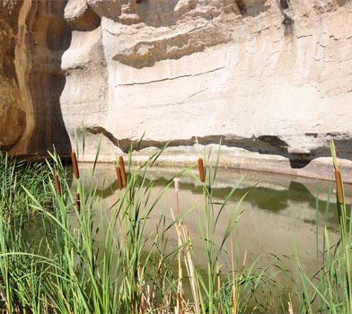
Spanish settlers arrived here during the 16th and early 17th centuries and gave the name "El Morro" (The Headland) to this high desert grassy land. One of the oldest inscriptions was carved by Don Juan de Oate on the 16th of April 1605. Oate was a conquistador from New Spain and the colonial governor of Nuevo Mxico. Oate is known for his brutal retaliation against the Acoma Pueblo in 1599, known as the Acoma Massacre or the Battle of Acoma Pueblo. Over a century after the first inscription was carved, many Spanish families, missionaries and military officers continued to visit the pool of water at the base of the sandstone cliffs. The last recorded Spaniard carving was made by Andres Romero in the year 1774.
During the early 1800's, American military and many Anglo-American pioneer families stopped at El Morro to rest and drink from the pool of water. Many carved their names in the sandstone cliffs. Some of the more famous inscribers are renowned explorers. Lieutenant Edward Beale carved his name in 1857 as he passed the area with his US Army expedition team who were hired by the US government to chart and build a transcontinental wagon road. At the time, Beale was also testing the usefulness of using camels in the rough desert environment. Peachy Breckenridge (the son of Vice President John C. Breckenridge) was responsible for the care of the camels, and he carved his name in the sandstone cliffs during his second trip in 1859. Beale wrote positively about the camels in his journals, but the Army abandoned the experiment at the onset of the Civil War. After his work with Beale, Breckenridge returned to his home state of Virginia and fought in the Civil War. According to the booklet provided by the park service, Breckenridge was killed during a skirmish at Kennon's Landing, Virginia in 1863.
Before visiting this unique piece of American history, stop by the visitor center and ask for a copy of their in-depth, informative booklet. Read about the history of the inscriptions as you follow the trail.
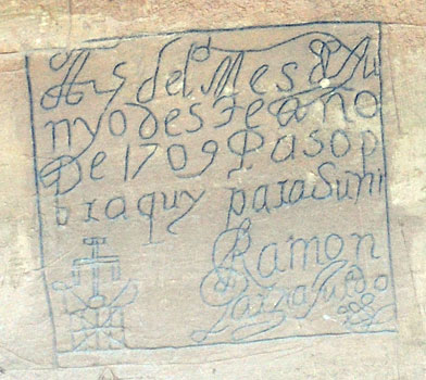
Translation of the above inscription: "On the 25th of the month of June, of this year of 1709, Ramn Garca Jurado passed through here on the way to Zuni." According to the booklet provided by the park service, it was likely that Jurado was on a campaign against the Navajos during his visit to El Morro in 1709.
Elevation
The Inscription Trail has a maximum elevation of 7,268 ft., a minimum elevation of 7,196 ft. and an elevation range of 72 ft.
Metrics
| [ A to B ] or [ B to A ] | |||
|---|---|---|---|
| Length 2 | Min Ele 3 | Max Ele 4 | Range 5 |
| 0.4 mi | 7,196 ft | 7,268 ft | 72 ft |
| [ A to B ] | |||
|---|---|---|---|
| Time 6 | Floors 7 | Gain 8 | Loss 9 |
| 10 min | 5.8 | 69 ft | 69 ft |
| [ B to A ] | |||
|---|---|---|---|
| Time | Floors | Gain | Loss |
| 10 min | 5.8 | 69 ft | 69 ft |
Calories
The following chart shows the total calories that you may expend on the trail while hiking in both directions. The chart is based on data derived from a statistical model of energy expenditure that relates gross weight, typical speed and trail topography.
Topo Maps
Download the PDF Inscription Trail topo map and the adjoining quads to plan your hike. These are full-sheet, 7.5 Minute (1:24,000 scale) topographic maps.
Adjoining 7.5' Quadrangle Legend
- Northwest Topo Map: Ramah, NM
- North Topo Map: Kettner Canyon, NM
- Northeast Topo Map: Post Office Flat, NM
- West Topo Map: Togeye Lake, NM
- Topo Map: El Morro, NM
- East Topo Map: Valle Largo, NM
- Southwest Topo Map: Nicoll Lake, NM
- South Topo Map: Goat Hill, NM
- Southeast Topo Map: Cerro Hueco, NM
FAQ
What is the length of the Inscription Trail?
The length of the trail is 0.4 miles (0.7 km) or 909 steps.
How long does it take to hike the Inscription Trail?
A person in good physical health can hike the trail in 10 minutes in one direction and in 10 minutes in the opposite direction.
Warnings
Prevent tick bites: Treat clothing and gear, such as boots, pants, socks and tents with products containing 0.5% permethrin.
(cdc.gov)
- The Brown dog tick (Rhipicephalus sanguineus) may be present in this area. The Brown dog tick transmits Rocky Mountain Spotted Fever.
Footnotes
- Steps is a unit of distance equal to the sum of stride lengths that vary with the terrain.
- Length is the distance of the trail between the two trailheads, measured on the trail.
- Min Ele is the minimum elevation on the trail.
- Max Ele is the maximum elevation on the trail.
- Range is the difference between maximum and minimum elevation.
- Time is the typical total time required to hike the trail.
- Floors is the gain divided by twelve feet, the height of one floor.
- Gain (cumulative elevation gain) is the sum of every gain in elevation.
- Loss (cumulative elevation loss) is the sum of every loss in elevation.
